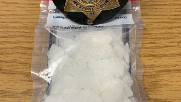
Athens-Limestone under tornado watch until 5 p.m. Tuesday
UPDATE: 12:08 p.m.
“We are getting a few power lines and trees down call,” Brandon Wallace at the 911 Center alerted The News Courier.
UPDATE: 12:06 p.m.
The National Weather Service in Huntsville has issued a
* Flash Flood Warning for…
Limestone County in north central Alabama…
Northwestern Morgan County in north central Alabama…
Northeastern Lawrence County in northwestern Alabama…
* Until 200 PM CST.
* At 1155 AM CST, emergency management reported thunderstorms
producing heavy rain across Central Limestone, far Northwestern
Morgan, and Northeastern portions of Lawrence Counties. Flash
flooding is ongoing or expected to begin shortly.
HAZARD…Flash flooding caused by thunderstorms.
SOURCE…Emergency management reported.
IMPACT…Flash flooding of small creeks and streams, urban
areas, highways, streets and underpasses as well as
other poor drainage and low-lying areas.
* Some locations that will experience flash flooding include…
Decatur, Athens, Trinity, Courtland, Tanner, Harvest, North
Courtland, Hillsboro, Elkmont, Ripley, Cartwright, Coxey, French
Mill, Caddo, Wheeler and Capshaw.
FLASH FLOOD…OBSERVED
UPDATE 12:02 p.m.:
Special Weather Statement
National Weather Service Huntsville AL
1159 AM CST Tue Jan 3 2023
ALZ004>007-031830-
Lawrence AL-Madison AL-Morgan AL-Limestone AL-
1159 AM CST Tue Jan 3 2023
…A strong thunderstorm will impact portions of southwestern
Madison, southeastern Limestone, Morgan and east central Lawrence
Counties through 1230 PM CST…
At 1158 AM CST, Doppler radar was tracking a strong thunderstorm near
Decatur, moving east at 55 mph.
HAZARD…Winds in excess of 40 mph.
SOURCE…Radar indicated.
IMPACT…Gusty winds could knock down tree limbs and blow around
unsecured objects.
Locations impacted include…
Huntsville, Decatur, Madison, Hartselle, Redstone Arsenal, Moores
Mill, Priceville, Trinity, Owens Cross Roads and Triana.
PRECAUTIONARY/PREPAREDNESS ACTIONS…
If outdoors, consider seeking shelter inside a building.
This storm may intensify, so be certain to monitor local radio
stations and available television stations for additional information
and possible warnings from the National Weather Service.
A Tornado Watch remains in effect until 500 PM CST for north central
and northwestern Alabama.
&&
LAT…LON 3469 8718 3482 8652 3448 8642 3448 8650
3450 8654 3454 8655 3445 8657 3438 8713
TIME…MOT…LOC 1758Z 259DEG 49KT 3454 8705
MAX HAIL SIZE…0.00 IN
MAX WIND GUST…40 MPH
UPDATE: “We are under a Tornado Watch so this is time to stay weather aware and know where their safe place is and keep monitoring the weather in case they need to go into safe area/room/basement,” Daphne Ellison with the Limestone EMA said. “They should have multiple ways to get Weather Alerts and Warnings such as weather radio, smart911, mobile apps, etc. Do not rely on the sirens.”
The National Weather service has issued Tornado Watch 7 in effect until 5 p.m. CST Tuesday for the following areas:
In Alabama this watch includes eight counties.
In North Central Alabama:
Cullman, Limestone, Madison, Morgan
In Northwest Alabama:
Colbert, Franklin, Lauderdale, Lawrence
In Tennessee this watch includes three counties.
In Southern Middle Tennessee:
Franklin, Lincoln, Moore
This includes the cities of Athens, Cowan, Cullman, Decatur, Decherd, Estill Springs, Fayetteville, Florence, Huntsville, Lynchburg, Moulton, Muscle Shoals, Red Bay, Russellville, Sewanee, Sheffield, Town Creek, Tuscumbia, and Winchester.