Strong storms likely Thursday
Published 5:41 pm Wednesday, March 29, 2017
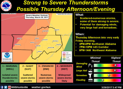
- Storm map 3/30/17
Strong-to-severe storms are possible Thursday, according to a hazardous weather outlook issued late Wednesday afternoon by the National Weather Service in Huntsville.
Two rounds of storms are expected to impact the area, though it’s the second round of storms — anticipated to arrive by late Thursday afternoon — that could be the most severe. Damaging winds of over 60 mph, large hail and tornadoes are all possible, the outlook said. One-to-two inches of rainfall is also likely.
Trending
Limestone County is in the “enhanced risk” category for severe weather, while about half of neighboring Lauderdale County is in the moderate risk category. The strongest storms are anticipated along and just west of the Interstate 65 corridor.
The threat of severe weather will somewhat diminish late Thursday evening, but damaging winds and large hail could still be possible. The overall threat will diminish by early Friday morning with the passage of the cold front.
Strong-to-severe storms could again impact the Tennessee Valley Monday and Tuesday.
Trending


-
eEdition
-
-
