NWS: Tornado paths for 1974, 2011 match
Published 6:55 am Wednesday, December 28, 2011

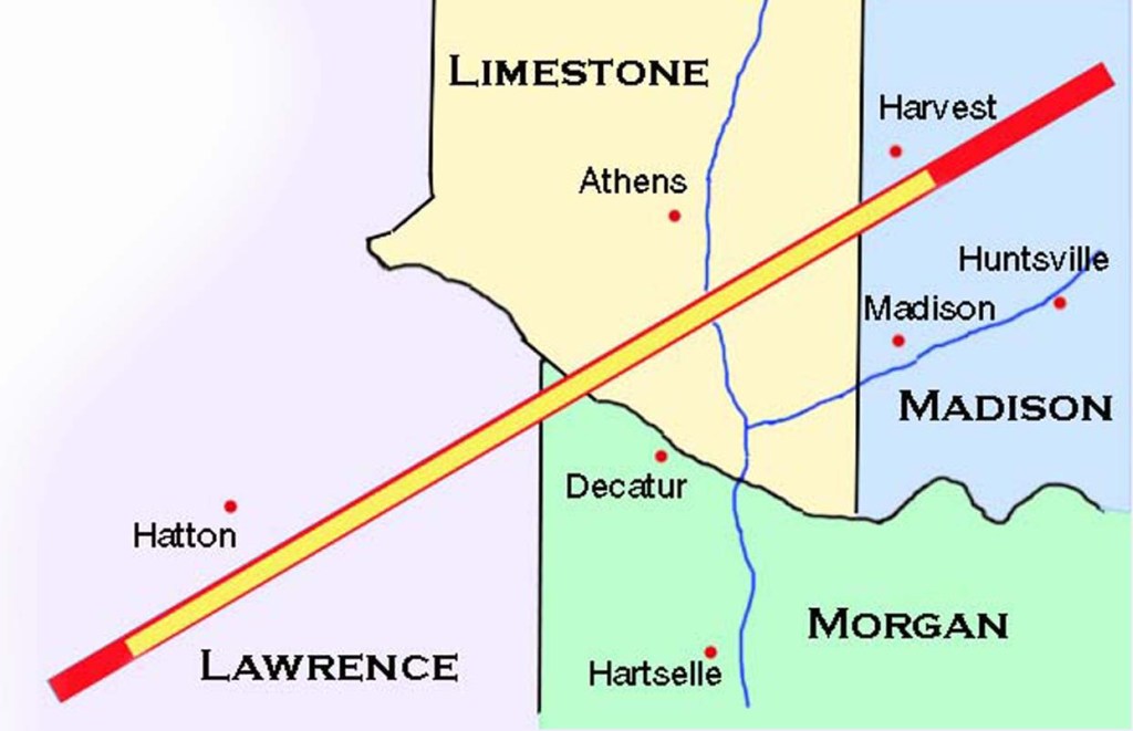
- The red line shows the path of the April 27 EF5 tornado through Limestone County. The yellow line shows the path of the April 3, 1974, F5 twister.
After having two homes blown from the same foundation by tornadoes in 1974 and 2011, Jean Bond is philosophical. Just days after the April 27 tornado outbreak that devastated much of Limestone County, the 70-something grandmother quipped that she wasn’t afraid to rebuild because, if the storms come every 37 years, she won’t be around for the next one.
Bond was one of several families that experienced the rare phenomenon of being hit twice by deadly tornadoes in the same spot.
Unlike the old wives’ tale about lightning, it seems tornadoes have no compunction about revisiting old haunts.
On April 3, 1974, Limestone County — the communities of Tanner and East Limestone in particular — was struck by two massive and powerful twisters within 30 minutes on the same path. An F5, the highest ranking on the Fujita scale that marks the deadliest tornadoes, tore through the county at about 5 p.m., followed by an F4 twister at about 5:30 p.m. Sixteen people died and hundreds of homes were demolished.
The 1974 tornadoes were part of what became known as the Super Tornado Outbreak because of the widespread damage and fatalities it caused: 148 tornadoes struck 13 states, killing 351 people.
Books were written about the rare weather event, and Limestone Countians mark the anniversary of the storms each year by reminiscing, sharing photos and telling their stories to The News Courier. On April 20, 2011, The News Courier published a story about Jimmy Williams of East Limestone, who took cover in 1974 in a ditch with his family. They survived, though Williams’ 5-year-old son was hospitalized after the mud pushed into his ears by the strong winds led to infection.
Exactly a week after Williams’ recollections of 1974 were published, the Williams home was struck again, as was Jimmy’s Greenhouse, the family business on the same property.
The tornado that came on April 27 — one of seven in Limestone County that day and 62 in the state — was an EF5, the highest ranking on the new Enhanced Fujita Scale.
Four people were killed here, and 247 were killed statewide.
Like residents of Tanner and East Limestone, News Courier reporters immediately noted the similarity of the paths of the 1974 and 2011 twisters.
Because of the widespread damage — more than 700 homes and 84 businesses hit here — it would be many months before officials with the National Weather Service in Huntsville would have enough data collected for comparisons. But NWS meteorologist Tim Troutman and University of North Alabama geography professor Greg Gaston already had some statistics: They had began a study in 2008 to see what would happen is storms of the magnitude of 1974 struck again, taking into consideration more densely populated areas. They also were hoping to determine if tornadoes had preferred tracks.
So when the events of April 27 unfolded, they were not surprised at the scope of the destruction because more homes and businesses were located in the storm’s path than 37 years before.
However, fatalities were fewer in 2011, most likely due to better warnings.
It wasn’t until Troutman and Gaston compared the tracks of the deadliest tornadoes on those days — the F5 in 1974 and the EF5 in April of 2011 — that the evidence seen on the ground was confirmed: The two paths match almost exactly. (See map)
In addition, the path of the F4 that struck a half hour after the first twister in 1974 mirrored the other tracks.
Jean Bond, who took cover on April 27 in the underground shelter she insisted her husband add on their property following the 1974 twisters, was spared the wrath of the storm because she took cover in the shelter. Her adult children — two sons and a daughter — took shelter with her. Everyone in the family lost their homes that day.
Jimmy and Lynda Messer
A preferred path?
With the study begun in 2008, Troutman and Gaston hoped to determine if tornadoes have preferred paths. If so, they wanted to know which paths seemed common and why in hopes of providing better understanding of tornadoes and, in turn, foster better preparedness and warnings.
“There are signs there are preferred tracks,” Troutman said, but cautioned: “the data is very preliminary.”
While it is too early to form certainties, Troutman said it appears as if topography can impact tornado tracks. For example, some tracks seem to be formed from winds coming off mountains in the Huntsville area, then twisting as they reach the flatlands of Limestone County.
However, Gaston said some April 27 supercells formed 5 to 6 miles in the air, which would make topography less relevant.
“What I’m trying to do is look for persistent patterns,” Gaston said. “The next step is to come up with some reason why.”
Troutman said “much more research” needs to be done to determine reasons for the patterns.
“We want to have an understanding of the threat to the Tennessee Valley region,” he said. “What folks have to understand in this region is that it’s not a matter of if, but when. The Important thing is that we be ready and understand what to look for.”


